
TROPOMI provides global coverage, with daily revisit time, but it primarily detects emissions of >10 t/h, due to the large effective pixel size of the TROPOMI instrument [6]. Therefore, other techniques are also needed, to detect smaller point source emissions.
Methane point source monitoring using Sentinel-2 is an area of active development for us. Sentinel-2 methane enhancement has a minimum detection limit of 1 to 3 t/h [6]. That is over bright, even ground in light wind. Coal and spoil reflect far less shortwave infrared, and a working pit changes from one pass to the next, so over a mine the same instrument needs several times more: a single large vent sits near the edge of what it can see. For many point source emissions, this is significant. Consider, for example, that vents of large underground coal mines typically emit methane in the range of 1 to 10 t/h, so likely outside the range of TROPOMI detection [7].
With a spatial resolution of 20m in the methane sensitive bands (B11/B12), global coverage, and open source availability, Sentinel-2 is positioned to make an important contribution to point source methane monitoring. The high revisit time of Sentinel-2 is also suited to monitoring point sources, which are often intermittent in nature.
Where our R&D sits
In our previous article we discussed Sentinel-2 processing for methane enhancement [8, 9, 10, 11], so here we will just focus on our active areas of R&D. This area has considerable scope for innovation and, as such, the study by Sherwin et al. is particularly useful [6]. In this study, the authors released a number of controlled methane pulses, which were timed to coincide with Sentinel-2 (and other) satellite overpasses. The controlled nature of these releases means that they can be used as a development sandbox. Some of these point source releases were also small, so we can begin to explore the limits of detection.
In the first instance, we have implemented, and evaluated, the method reported by Ehret et al. where we compute a background image from a time series of plume-free Sentinel-2 products [12]. This optimised background image is then subtracted from our plume-positive image during the plume enhancement process. This process can be combined with other image processing modalities, to improve enhancement. The correct combination of techniques becomes particularly important when the target emission approaches the limit of detection. These may include Gaussian filtering [12], co-registration of Sentinel-2 images [12, 13], and also image normalisation [14].
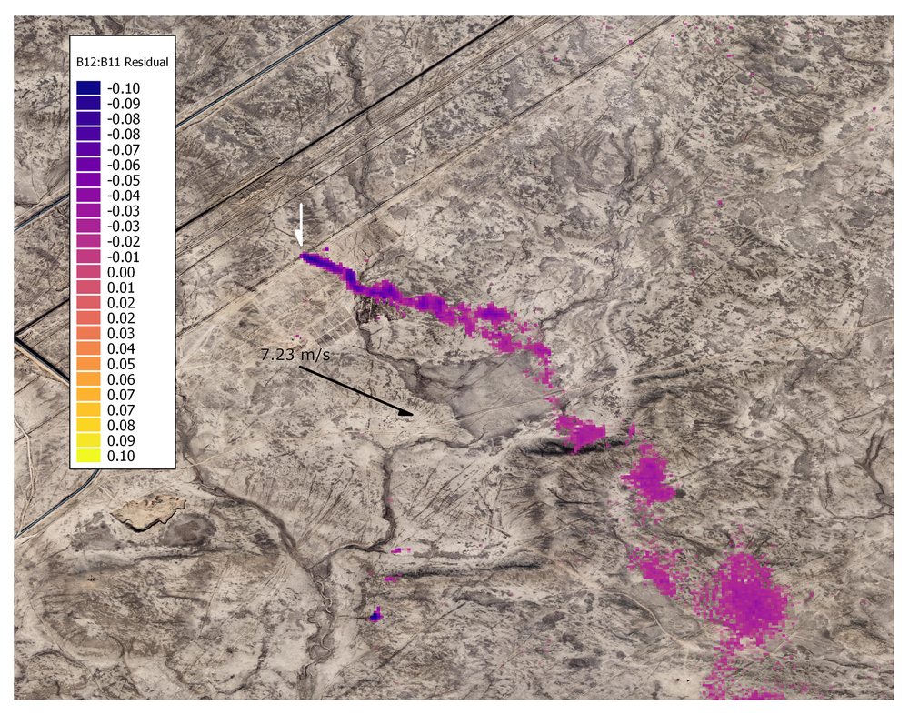
Testing against the limit of detection
We have also been testing our plume enhancement methodology with much smaller emissions, from the Sherwin et al. dataset [6]. For example, we picked out a controlled release of just 1.4 t/h over a bright, uniform surface. This emission is close to the limits of detection using current methods. It was actually missed by some participants in the Sherwin et al. study [6].
We are currently investigating whether Sentinel-2 can be used for the persistent monitoring of emissions from coal mine ventilation shafts. As previously discussed, these emissions are often below the threshold for TROPOMI detection (1 to 10 t/h), but also likely an important contributor to anthropogenic warming. In the 2020 paper by Varon et al. [7], the authors detected and quantified wind-rotated mean GHGSat products over coal mine vents. We have discussed wind rotation in the context of TROPOMI, but we suggest that it should also be considered for Sentinel-2, where mean products may be able to push the lower limit of detection.
Lastly, analogous to the discussion above regarding TROPOMI data, the detection of Sentinel-2 methane emissions may be automated using AI modalities, and this is an area of active research for us. Indeed, in the context of emissions approaching the limits of detection, AI modalities may be particularly significant.
References
- Sherwin, E.D., Rutherford, J.S., Chen, Y., Aminfard, S., Kort, E.A., Jackson, R.B. and Brandt, A.R., 2023. Single-blind validation of space-based point-source detection and quantification of onshore methane emissions. Scientific Reports, 13(1), p.3836.
- Varon, D.J., Jacob, D.J., Jervis, D. and McKeever, J., 2020. Quantifying time-averaged methane emissions from individual coal mine vents with GHGSat-D satellite observations. Environmental Science & Technology, 54(16), pp.10246-10253.
- Gorroño, J., Varon, D.J., Irakulis-Loitxate, I. and Guanter, L., 2023. Understanding the potential of Sentinel-2 for monitoring methane point emissions. Atmospheric Measurement Techniques, 16(1), pp.89-107.
- Varon, D.J., Jervis, D., McKeever, J., Spence, I., Gains, D. and Jacob, D.J., 2021. High-frequency monitoring of anomalous methane point sources with multispectral Sentinel-2 satellite observations. Atmospheric Measurement Techniques, 14(4), pp.2771-2785.
- Sánchez-García, E., Gorroño, J., Irakulis-Loitxate, I., Varon, D.J. and Guanter, L., 2022. Mapping methane plumes at very high spatial resolution with the WorldView-3 satellite. Atmospheric Measurement Techniques, 15(6), pp.1657-1674.
- Mayer, B. and Kylling, A., 2005. The libRadtran software package for radiative transfer calculations, description and examples of use. Atmospheric Chemistry and Physics, 5(7), pp.1855-1877.
- Ehret, T., De Truchis, A., Mazzolini, M., Morel, J.M., D'aspremont, A., Lauvaux, T., Duren, R., Cusworth, D. and Facciolo, G., 2022. Global tracking and quantification of oil and gas methane emissions from recurrent Sentinel-2 imagery. Environmental Science & Technology, 56(14), pp.10517-10529.
- How to Co-Register Temporal Stacks of Satellite Images, EOResearch. https://medium.com/sentinel-hub/how-to-co-register-temporal-stacks-of-satellite-images-5167713b3e0b
- Zhang, Z., Sherwin, E.D., Varon, D.J. and Brandt, A.R., 2022. Detecting and quantifying methane emissions from oil and gas production: algorithm development with ground-truth calibration based on Sentinel-2 satellite imagery. Atmospheric Measurement Techniques, 15(23), pp.7155-7169.