
The Sentinel-5 satellite, equipped with the TROPOMI sensor, is changing how we track methane emissions. A processing technique called wind rotation is sharpening TROPOMI's focus, revealing methane point sources from coal mines in Australia with far more clarity. This article covers how wind rotation enhances TROPOMI data, with specific examples of methane plumes isolated from active and inactive mines. We also discuss ongoing research into smaller methane sources, and efforts to validate these findings with ground-based measurements and higher-resolution satellite data.
Data provided by the TROPOMI sensor, of Copernicus Sentinel-5, has established itself as an important tool in the remote sensing of anthropogenic methane. With its repeat time of 1 day, TROPOMI data is excellent for detecting large emission events. Its spatial resolution, at 7 x 5.5 km2, has previously been insufficient to pinpoint methane point sources. However, a processing technique can enhance TROPOMI data, and allow point sources to be localised with more confidence.
Wind rotation
First reported by Maasakkers et al. [1], wind rotation is a simple but effective technique for enhancing methane plumes in TROPOMI imagery. In doing so, it can be used to localise methane emissions, and to inform the targeting of more fine grained imaging, such as that produced by GHGSat [2].
The technique has three stages, for a given area of interest and time window. First, the spatial resolution of TROPOMI data is enhanced via spatial binning. Second, each TROPOMI product is rotated to true north, around a fixed point, based on historical wind data. Last, the stack of TROPOMI products is reduced into a single, wind-rotated mean product. This process is then repeated over a grid of rotation centres. Candidate plumes are then evaluated, and the best enhancement selected. The point of rotation of the optimal plume corresponds to its point of emission.
The Raspadskaya coal mine methane emission in Kemerovo Oblast, June 2022, demonstrates the process [3]. As the rotation centre gets closer to the point of emission, the plumes become more coherent.
Maasakkers et al. [1] gave the example of a landfill in Buenos Aires, an analysis we have repeated. Spatially binned but unrotated mean TROPOMI data shows little. Applying wind rotation with an optimal rotation centre results in a clear enhancement of a methane plume.
Applied to Australian coal mines
We have been exploring how this technique can be developed, and applied to the detection of methane emissions from Australian coal mines. In some cases, where TROPOMI data is sufficiently rich, the technique can be applied to monthly TROPOMI data.
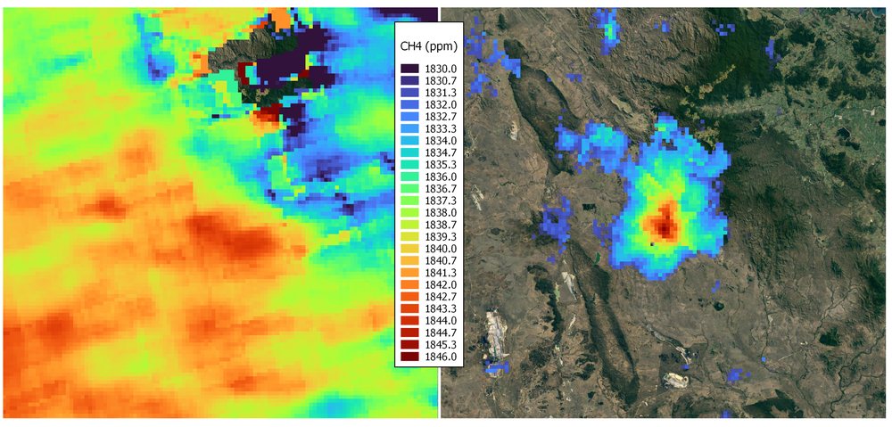
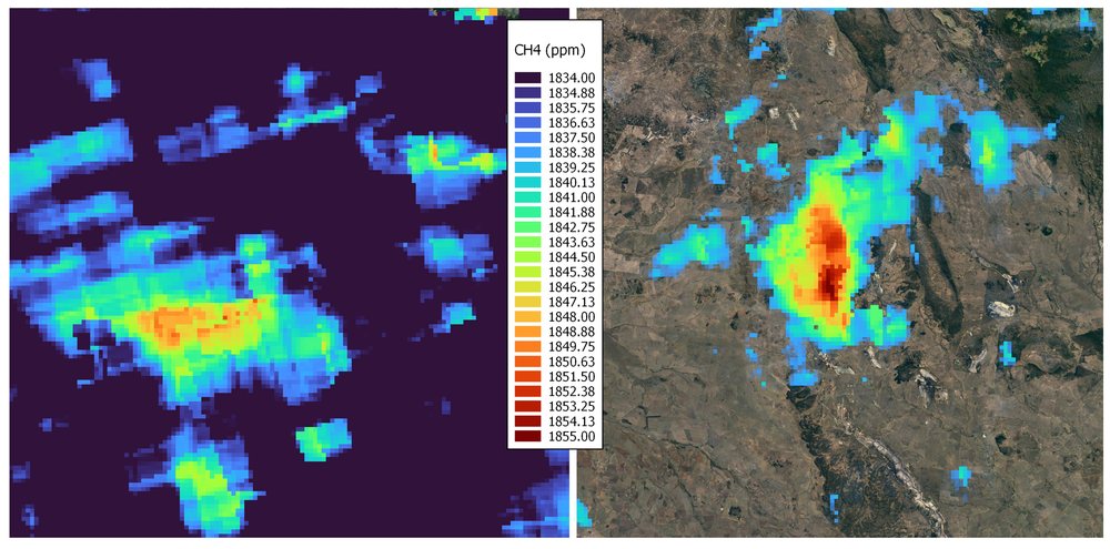
With the requisite domain knowledge, both spatial (mine structure) and temporal (mine activity), we can attempt to interpret the cause of the observed emission.
Research and development: ground truthing
As with all approaches that are not based on direct measurement, it is important to validate findings using ground truth data. In the context of methane emissions, this could take a number of forms.
First, NGER reporting requires that mines undertake periodic in situ methane monitoring, and access to this data would enable direct correlation of ground truth and remote sensed methane [7]. Second, in the context of farm dam methane, Blue Carbon Labs have undertaken a number of direct measurement field studies [5].
Third, ground truthing could be achieved using an alternative remote sensed product with higher spatial resolution, such as GHGSat [2]. Although less accurate than in situ monitoring, GHGSat still has an effective spatial resolution of 25m, allowing for the validation of emissions identified by TROPOMI [8].
Lastly, because of the spatial and temporal resolution of TROPOMI, screening of large areas is possible. The fact that candidate plumes need to be evaluated by eye, and the best enhancement selected, is potentially limiting. However, with a sufficient dataset, it is plausible that a machine learning model could be trained to predict plume enhancement from input plume candidates. This would enable almost real time wind-rotated TROPOMI screening, simultaneously, for multiple locations.
References
- Maasakkers, J.D., Varon, D.J., Elfarsdóttir, A., McKeever, J., Jervis, D., Mahapatra, G., Pandey, S., Lorente, A., Borsdorff, T., Foorthuis, L.R. and Schuit, B.J., 2022. Using satellites to uncover large methane emissions from landfills. Science Advances, 8(31), p.eabn9683.
- GHGSat, Methane emissions from opencast coal mines measured from space. https://www.ghgsat.com/en/newsroom/world-first-methane-emissions-from-opencast-coal-mines-measured-from-space/
- GHGSat report of the Raspadskaya coal mine methane emission, Kemerovo Oblast, 15 June 2022. https://www.ghgsat.com/en/newsroom/russian-mine-produces-biggest-methane-leak-ever-seen-by-ghgsat/
- Ember, Abandoned Mine Methane. https://ember-climate.org/insights/research/tackling-australias-coal-mine-methane-problem/
- Blue Carbon Labs, Australian farm dam methane. https://www.bluecarbonlab.org/farm-dams/
- Huber, D.E., Steiner, A.L. and Kort, E.A., 2020. Daily cropland soil NOx emissions identified by TROPOMI and SMAP. Geophysical Research Letters, 47(22), p.e2020GL089949.
- Estimating emissions and energy from coal mining guideline (NGER). https://www.cleanenergyregulator.gov.au/DocumentAssets/Documents/Estimating%20emissions%20and%20energy%20from%20coal%20mining%20guideline.pdf
- ESA summary of GHGSat. https://earth.esa.int/eogateway/missions/ghgsat